


col des Ruillans -gare du Peyrou d'Amont

geranimo
User
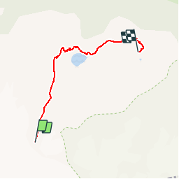

Length
4.4 km

Max alt
3195 m

Uphill gradient
108 m
Km-Effort
8.5 km

Min alt
2320 m

Downhill gradient
880 m
Boucle
No
Creation date :
2019-11-11 14:55:37.734
Updated on :
2019-11-23 17:00:42.722
--
Difficulty : Medium

FREE GPS app for hiking
 SityTrail
IGN / Geographical institutes
SityTrail Plus
The world is yours!
About
Trail On foot of 4.4 km to be discovered at Provence-Alpes-Côte d'Azur, Hautes-Alpes, La Grave. This trail is proposed by geranimo.
Positioning
Country:
France
Region :
Provence-Alpes-Côte d'Azur
Department/Province :
Hautes-Alpes
Municipality :
La Grave
Location:
Unknown
Start:(Dec)
Start:(UTM)
284370 ; 4987727 (32T) N.
Comments